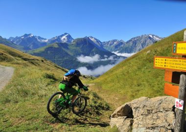
Return hike to La Garde-en-Oisans_Auris-en-Oisans
A long hike that winds partly through the Auris spruce forest and past charming little hamlets.
À propos : La Garde-en-Oisans – Hiking from the resort of Auris-en-Oisans
MAP AND HIKING GUIDE
OBP (Oisans au Bout des Pieds) hiking guides/maps Nos. 2 and 3, available for purchase at the tourist office: trails 303 and 270.
IGN Top 25 Bourg d’Oisans and L’Alpe d’Huez 3335 ET.
ITINERARY
You’ll set off directly from the tourist office and cross through the resort before entering the protected Piégut Forest. The downhill trail will take you deep into Europe’s highest spruce forest.
A series of switchbacks will lead you to a ridgeline trail where you can enjoy magnificent views of the Bourg plain—and beyond—until you reach the hamlets of Armentier-le-Haut and Armentier-le-Bas. Shortly after crossing the Sarenne River, you’ll arrive in the town of La Garde-en-Oisans.
Accueil : Be sure to bring plenty of water, shoes suitable for walking, a hat or cap, and sunscreen.
Tips
Keep in mind: part of the trail is exposed. You may be caught off guard by the sun, wind, or rain. Be sure to check the weather forecast before setting out on the hike.
History, culture and heritage
Unusual: With its eleven hamlets spread across an elevation range of 720 to 1,450 meters, La Garde-en-Oisans is one of the most vertically diverse towns in France!
Guidebook with maps/step-by-step
From the Tourist Office, leave Place des Orgières by turning right onto Rue de Piégut. At the curve, across from the basketball court, you’ll find the trailhead, which leads into the forest. A signpost directs you toward Plancet, among other destinations.
Soon after, a second signpost continues to point you in this direction. At the next intersection, keep following the signs for Plancet. Just before reaching the hamlet of Plancet, the dirt trail descends steeply, requiring your full attention. Once in Plancet, a picnic table invites you to take a break, while signs point toward La Balme and Le Cert.
You’ll then take a winding trail to your right, following the direction of L’Armentier-le-Haut. You’ll need to walk briefly along the D211A road before turning right at a yellow sign warning of a tricky section due to possible rockfalls. You’ll follow a trail running along the mountainside until you exit the hazardous area.
In the hamlet of L’Armentier-le-Haut, a sign points you toward L’Armentier-le-Bas. You’ll pass along the edge of the hamlet of L’Armentier-le-Bas before continuing toward La Ville and La Garde–La Meule. You’ll pass through the hamlet until you reach the Sarenne River, continuing in the direction of Bourg-d’Oisans and La Garde–La Meule. After crossing the river, follow the road for a short stretch toward La Garde–La Meule before reaching the town of La Garde-en-Oisans, the destination of this hike.
The return trip follows the same route in the opposite direction.
En bref
D+ : 1240 m
17.88 km
Level black - very hard
Plan et tracé GPX
La Garde-en-Oisans – Hiking from the resort of Auris-en-Oisans
Auris-en-Oisans
Équipements
- Free car park
- Parking nearby
- Car park
- Public WC
Services
- Pets welcome
À télécharger
Ouverture
From 01/05 to 31/10/2026 daily.
The periods during which the trails are accessible vary from year to year depending on snow cover and weather conditions. In addition, trail conditions can change rapidly after a weather event and are not checked daily. If you encounter a section of the trail that is in poor condition or dangerous, turn back and report it to the tourist office.
Tarifs
Free access.
Accueil animaux
Dogs must be kept on a leash throughout the town and on all trails.