Col de Maronne – snowshoeing from Auris-en-Oisans_Auris-en-Oisans

Col de Maronne – snowshoeing from Auris-en-Oisans_Auris-en-Oisans
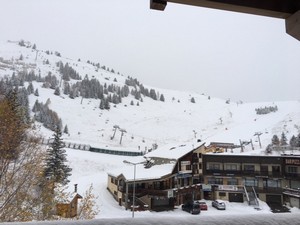
From the resort, embark on a hike to the Col de Maronne, from where you can observe the 2 Alpes glaciers and the Grandes Rousses!
À propos : Col de Maronne – snowshoeing from Auris-en-Oisans
TECHNICAL INFORMATION
Start: Place des Orgières
Height difference: 110 m
Round trip time: 1 h
Round trip distance: 3.2 km
Level: easy (green)
MAP AND TOPO
Pedestrian and Nordic map of the Alpe d'Huez ski area (available from the tourist office).
ITINERARY
Take the stairs in front of the Vacancéole - Les Écrins d'Auris residence. Walk up towards the ski slopes, then take the pedestrian path around the residence to the left. You'll first pass through a wooded area, then gain height and a clearer view of the Auris surroundings. Once you reach the Col de Maronne, a view of the glacier des é Alpes and the Grandes Rousses awaits you. The itinerary includes a return by the same route, but you also have the option of continuing to the Plateau de la Rochette, from where you can take the Auris Express chairlift back to the resort.
This itinerary is part of the cross-country ski loop.
TO SEE ALONG THE WAY
View of the resort and slopes
View of the Écrins
View of Alpe d'Huez
NEARBY SIGHTS
Auris-en-Oisans resort and hamlets
Visitor alert
ATTENTION:
Passage of sled dog teams on the course:
- mornings between 8am and 9am
- evening between 5pm and 6pm
+ Thursday evenings between 9pm and 10pm
It is not advisable to take your dog with you during these times.
En bref
1 h 00
D+ : 110 m
3.2 km
Level green – easy
Plan et tracé GPX
Col de Maronne – snowshoeing from Auris-en-Oisans
Auris-en-Oisans
Services
- Pets welcome
Prestations
Activités
- Durée séance : 60 minutes
Visites
- Durée moyenne de la individuelle : 60 minutes
Ouverture
From 06/12/2025 to 12/04/2026 daily.
Subject to favorable snow and weather conditions.
Tarifs
Free access.